Types of Clouds
Saturdays are perfect days for meteorological surprises. Surprise—we’re talking about the clouds today!
Have you ever spotted a fascinating cloud formation and wondered how it developed or whether it signaled a coming storm? Learning the basics of clouds can improve both your weather sense and English understanding!
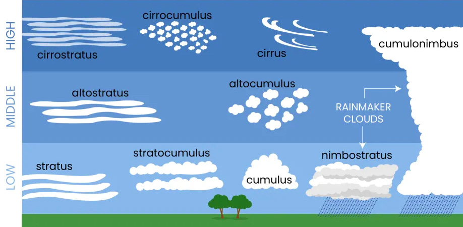
The names of the ten primary cloud types are derived from just five bases:
The root ALT- means high, as in altitude or exalt.
The root CIRR- means tendril or lock of hair, as in cirrose or cirriped.
The root CUMUL- means heap or pile, as in accumulate or cumulative.
Nimbus comes from the root NEB- meaning cloud, as in nebula and nebulous.
The root STRAT- means layer or spread, as in stratify or substrate.
LOW
Cumulus clouds are those classic fluffy clouds dotting serene blue skies. Enjoy them at your leisure, as they don't bring rain.
Stratus clouds cover the sky in low, thin sheets that carry little rain. They strongly resemble fog.
Cumulonimbus clouds might inspire awe or dread as they billow and tower into the atmosphere. These classic thunderheads are the only clouds that produce lightning and thunder, and sometimes even hail or tornadoes!
Stratocumulus clouds are patchy dark gray or white clouds that sometimes herald a storm.
Arcus clouds appear as low wedge-shaped (shelf) or rolling (roll) clouds typically associated with powerful storm clouds because they appear with cumulonimbus clouds.
BREAKDOWN: ARC- is the root for arch or bow, as in words like arc or archery.
Mammatus clouds describe the appearance of a cellular pattern of pouches hanging full of moisture from different types of clouds, often but not always full of rain.
BREAKDOWN: MAMM- is the root for breast or udder, as in words like mammary or mammogram.
Orographic clouds are formed by the forced lifting of air by mountains or other topographical features.
BREAKDOWN: ORO- (mountain) + GRAPH- (writing) + -IC (pertaining to)
MID
Altocumulus clouds appear in an array of rows of fluffy white or gray ripples. despite their full appearance, altocumulus clouds don’t often produce rain.
Altostratus clouds blanket the sky in a gray shroud full of rain or snow.
Nimbostratus clouds act like altostratus but are even darker, gloomier, and more laden with heavy precipitation.
Lenticular clouds appear as rounded or ovoid clouds, often layered in a "stack of pancakes" formation. They are formed orographically and often indicate turbulence.
BREAKDOWN: The root LEN- means lentil, descriptive of these lentil-shaped clouds.
HIGH
Cirrus clouds are delicate, wispy clouds that appear above 16,000 feet. These clouds signal a change in the weather.
Cirrostratus clouds are thin, white clouds that cover the whole sky like a veil. When you see a halo around the sun or the moon, precipitation is on the horizon.
Cirrocumulus clouds are thin, sometimes patchy sheet-like clouds that presage cold weather or, depending on where you live, a possible hurricane.
Noctilucent clouds, considered both the rarest and highest cloud formation, appear as particularly thin cirrus clouds of silver, blue, or ever orange. Noctilucent clouds are too high to affect weather but carry abundant atmospheric significance for scientists.
BREAKDOWN: NOCT- (dark) + LUC- (light) + -ENT (full of)
If you're interested in diving even more deeply into the classical roots behind cloud taxonomy, you'll love the American Meteorological Society page on cloud classification.


